from Midwest Bedrock: The Search for Nature’s Soul in America’s Heartland
by Kevin J. Koch
From the platform top of Monks Mound, I can see seven miles across the Mississippi River to the St. Louis Gateway Arch. You might say I’m seeing 900 years into the future.
Monks Mound is the largest of about 70 remaining Native American mounds at the Cahokia State Historic Site near Collinsville, Illinois, not far from the east bank of the Mississippi. A UNESCO World Heritage Site, Cahokia was a Native American city with as many as 20,000 residents by 1100 A.D., larger than London at that time. No American city surpassed its size until 1800.
The city once encompassed six square miles, including at least 120 mounds of varying types, and was the hub for numerous outlying villages as well.
By 1300 A.D. Cahokia had disappeared.
Cahokia Mound City
At long last, after many years of intentions and dashed plans, [my wife Dianne and I] finally arrived at the Cahokia Mounds State Historic Site near Collinsville, Illinois, in September 2021. The slim fallen leaves of a young walnut tree—first victims of the encroaching autumn—swirled in circles at our feet as we approached the visitor center. We soon lined up inside with a group to tour the grounds under the tutelage of a young archaeology graduate named Matt.
Outside, the morning was already blasting warm for September, around 80 and pushing higher. We clustered in the building’s shade while Matt set the context. Human habitation in the region, as throughout most of the Midwest, he said, had begun 12,000 years ago as the glaciers to the north began their retreat. Cultures evolved over time from hunting and gathering to cultivation, adapting as the climate gradually grew warmer.
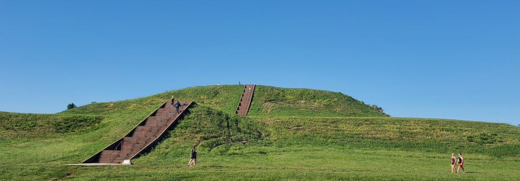
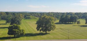
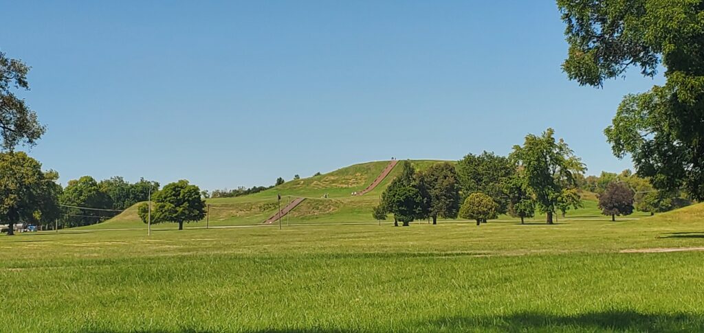
We ventured out onto the gravel path. The grounds were a blistering green, the grass short-clipped. The mounds, differently sized and shaped, seemed scattered. A long empty field stretched before us. In the distance I could see Monks Mound, the iconic, stair-stepped Cahokian structure I knew best prior to our visit.
The city known today as Cahokia, Matt told us, took hold around 800 A.D. and reached its zenith around 1050 as a renaissance took hold in the American Bottom. At a base level, the renaissance stemmed from an agricultural revolution focused on growing the “three sisters” of beans, squash, and corn. The development of an agricultural diet allowed for greater food storage, enabling large populations to live together. Freedom from the constant search for food in turn fueled the renaissance in architecture, artwork, leisure activities, and spirituality.
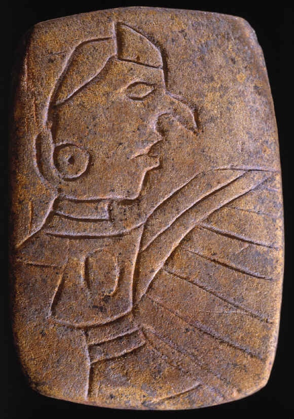
Artifacts unearthed at Cahokia place the city squarely in the Mississippian culture that flourished from Florida to Wisconsin at that time: the bird man tablet with its imagistic references to the Upper, Middle, and Underworld in the forms of bird, man, and serpent; and pipes with animal and human effigies. Other ceramics whose patterns and styles associated them with faraway places suggested extensive trade, immigration, and cultural interaction. (1)
Cahokia wasn’t an anomaly as a city of its time, but it was the most significant metropolis, perhaps the center, of the Mississippian culture.
The American Bottom positioned Cahokia for exponential growth. Annual flood silt kept croplands fertile. (2) Old Mississippi meanders and oxbows became lakes, sloughs, and marshes, suitable for fishing, clamming and gathering edible cattails. Nearby streams offered direct access to the Mississippi, which in turn—along with the Illinois and Missouri Rivers—provided trade and migration routes 800 miles in every direction. These routes would bring copper from the Great Lakes, mica from Appalachians, and seashells from Gulf of Mexico. (3)
The city, Matt explained, was also near prairies to the north, which provided not only game but also thatch for the many homes’ roofs, and to woodlands to the south and east for timber. The Cahokians felled many trees for their various needs, but spared pecans and walnuts for their fruits.
The city itself covered 4000 acres with at least 120 mounds. It ran three miles east to west, and more than two miles north-south. Its population, peaking between 1050-1200 A.D., may have reached 20,000, with some archaeologists putting it at 30,000. (4) Smaller villages surrounded Cahokia with 20,000 additional people, like modern suburbs. But Cahokia was the cultural and civic capital.
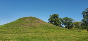
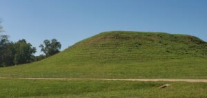
Matt led us among Cahokia’s most visible feature, its wealth of mounds, nearly 70 of which are still preserved at the historical site. They popped from the level field, round-topped, flat, or layered. Some stood nearly as tall as adjacent trees. Even the level field had been artificially sculpted by the Cahokians. The land would have been naturally mottled with small knolls and dips, created by swirling waters and siltation during floods. The Cahokians leveled the landscape in the city proper. And during the somewhat drier era in which the city flourished, annual floods typically didn’t reach as far inland as Cahokia. (5)
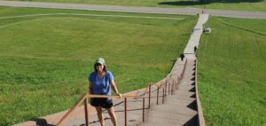
Monks Mound is premier among the platform mounds at Cahokia. Matt pointed in its direction but wouldn’t be taking us there as a group, due to the challenges of everyone climbing its 154 stairs to the top. Standing 100 feet tall on a base 1040 by 800 feet (19 acres), it is the largest Native American mound in North America, third largest in the world, slightly larger than the Great Pyramid of Egypt and the Pyramid of the Sun in Mexico. It was constructed by Cahokians carrying 22 million cubic feet of soil, sand, clay, and rock, basket by basket, from nearby floodplain “borrow pits,” (6) similar to all of the mounds at Cahokia. Some borrow pits were retained as ponds, but others were filled in with trash.
The long, open field we’d noticed running from the base of Monks Mound to the Twin Mounds where we now stood at the opposite end was the 1600-foot Grand Plaza, a rectangular public gathering space. Cahokians likely came to the Grand Plaza for markets and festivals, and for religious, civic, and sporting events. Acoustics in the valley could carry a booming voice from the top of Monks Mound out over the Grand Plaza. Matt took our imaginations back to some ancient feast with the high chief and shaman addressing thousands of Cahokians from on high, the sun glittering off metal ornaments at the top of the mound.
The gravel path that Matt led us on ran partially along the route of the stockade, a two-mile log wall that enclosed the interior of the city. The massive structure would have required 15-20,000 tree trunks, all brought in from beyond the city’s edge. The stockade’s purpose isn’t fully understood. It may, of course, have served a defensive role, but there is little evidence of extensive regional warfare during the period. It appears, though, to have divided the city’s hierarchy, with elites living within the enclosure and commoners on the outside in homes of pole and thatch construction, with areas for tool-making, cooking, storage, and sleeping. (7)
The Mississippian culture spread well beyond Cahokia, most likely through a combination of emigration, trade, and cultural exchange. Wisconsin’s Aztalan State Park has three platform mounds at a distance of 300 miles north of Cahokia. Trempealeau, Wisconsin, nearly 500 river miles to the north, likewise has three platform mounds overlooking the Mississippi, as well as artifacts directly linking the builders back to Cahokia. Mississippian influence likewise spread to the distant southeast.
Cahokia’s collapse after 1300 A.D. remains a mystery. There are several likely culprits, perhaps in combination. The city may have “collapsed under its own weight,” writes William Iseminger, as nearby forests and other resources were depleted. (8) Ill health may have resulted from water and air pollution and limited diets, all of which might have been mitigated in smaller communities. A cooling climate after 1250 may have led to shorter growing seasons, causing malnourishment. (9) And the cooling climate might have been accompanied by more frequent, destructive floods that reached the city proper. (10) Other locations might suddenly have looked more promising. Big game like bison, for example, were more common to the west. Perhaps Cahokia was beset by enemies, although no archaeological evidence points in that direction.
As Cahokians dispersed in different directions, they became or melded into historic-period tribes such as the Osage, Omaha, Kansa and the Missouri. Thirteen modern tribes claim descendancy from the Cahokian peoples.
The physical remains of the metropolis nearly disappeared. As St. Louis was founded and grew, its settlers razed mound sites west of the Mississippi. Of 40 mounds thought to have been located in the St. Louis area, 39 were destroyed. Some Europeans thought the mounds to be natural features that needn’t be preserved. At Cahokia itself, French priests built a chapel on first terrace of Monks Mound in 1730. (11) French Trappist monks then took up residence on the grounds from 1809-1813, growing crops on Monks Mound, hence giving it its modern name. (Cahokia itself takes its name from the unrelated Cahokia tribe who lived nearby in late 1600s.)
Cahokia continued slipping toward erasure from the landscape. A house was built on the top of Monks Mound in 1831. By the 1860s, much of the former city was being plowed and farmed. Powell Mound was destroyed 1930-31 to fill in a lowland for tillage (the lowland quite possibly being the borrow pit from which the mound was built in the first place). (12) Subdivisions encroached on the ancient city. A modern four-lane highway slashes through the Cahokian grounds, passing at the foot of Monks Mound. Interstate construction plans in the 1960s would have included an interchange at the edge of the grounds until its location was shifted.
But a preservation movement was already underway. Beginning in the 1830s and with each new slice of mound slated for destruction, archaeologists were establishing the extent and radiance of the city. The state of Illinois finally purchased 144 acres in 1925. In the ensuing decades, the state and the Cahokia Museum Society acquired 55 additional parcels, bringing the Cahokia Mounds State Historical Site to its present size of 2200 acres. Cahokia became a U.S. National Historic Landmark in 1965 and a UNESCO World Heritage Site in 1982, further ensuring its preservation. (13)

Later, Dianne and I took our own walk through the Cahokian grounds. Over here had sat the huts of the common people. Over there ran the wooden stockade. Before us lay the Grand Plaza. We hiked a trail winding in and out of the woods where we found more mounds in a remote clearing. Deer materialized at the edge of the forest, perhaps relieved that they’d arrived 700 years too late to be hunted. We walked across the road to Woodhenge, a reconstructed circle of 48 red cedar posts configured to mark the equinoxes, solstices, and other celestial events. I stood at the center post, aligning it with the perimeter post in the shadow of Monks Mound, where the Fall Equinox sun would rise.
We saved climbing Monks Mound till the end of our visit to Cahokia. The 154-step stairway ascends the mound in two segments divided by a level terrace halfway up.
At the platform’s top, the view stretches in all directions. Etched stone markers suggest what would have lain within sight in 1100 A.D. To the north lay the stream that linked the city to the Mississippi River. To the east were dwelling huts, the stockade, and more mounds. To the west, Woodhenge and the Mississippi River.  To the south, the Grand Plaza stretched out before the mound the length of a football field. Thousands of Cahokians might have gathered there to catch a glimpse of the high chief or shaman on a festival day.
Today, of course, the St. Louis Gateway Arch is likewise visible on the western horizon, completed in 1965 to commemorate the American westward expansion.
Whether a shaman with a vision of the future might have seen or sensed it back then, we’ll never know.
Illinois: Cahokia & the Upper Mississippi Shoreline. The View from the Center is a selection from Kevin Koch’s 2024 book, Midwest Bedrock: The Search for Nature’s Soul in America’s Heartland, published by Indiana University Press. This chapter is printed with permission. Copyright © 2024 by Kevin Koch![]()
Photographs courtesy of Kevin Koch, Dianne Koch and Cahokia Mounds State Historic Site.

Kevin J. Koch

Kevin J. Koch is author of Skiing At Midnight: A Nature Journal from Dubuque County, Iowa; The Driftless Land: Spirit of Place in the Upper Mississippi Valley; and The Thin Places: A Celtic Landscape from Ireland to the Driftless. More of his work, including shorter works on outdoor places and photos, can be viewed at his website.
This essay is selected from Koch’s book, Midwest Bedrock: The Search for Nature’s Soul in America’s Heartland, published in 2024 by Indiana University Press. It can be purchased here.
Koch is Professor of English at Loras College in Dubuque, Iowa.
Footnotes
1. Iseminger, William. Cahokia Mounds: America’s First City, 15.
2. Mink, Claudia. Cahokia: City of the Sun, 9-10.
3. Mink, 13.
4. Mink, 5.
5. Tyrrell, Kelly April. “As the River Rises.”
6. Mink, 24.
7. Mink, 31.
8. Iseminger, 149.
9. Mink, 66.
10. Tyrrell.
11. Mink, 68.
12. Iseminger, 36.
13. Belknap, Lori. Interview.
Bibliography
Belknap, Lori, Cahokia Mounds State Historical Site Superintendent. Interview by author. September 23, 2021.
Iseminger, William. Cahokia Mounds: America’s First City. The History Press, 2010.
Mink, Claudia. Cahokia: City of the Sun. Cahokia Mounds Museum Society, 1999.
Tyrrell, Kelly April. “As the River Rises: Cahokia’s Emergence and Decline Linked to Mississippi River Flooding.” University of Wisconsin-Madison News. May 4, 2015. https://news.wisc.edu/as-the-river-rises-cahokias-emergence-and-decline-linked-to-mississippi-river-flooding/